Getting There:
Getting to the Deer Creek Canyon is a fairly quick trip from anywhere in the Denver metro area. You can find the trail head here: 39.54382, -105.15175
Park in the spacious lot and look for the Plymouth Trail Sign to begin your ride.
The Ride:
You'll climb about 1000 feet over the course of 3.4 miles. After getting through the first quarter mile of the ride you can count on a 1.3 mile climb straight up, with virtually no flat spots. There are a few rock gardens that you'll run into on the way up. Nothing that can be ridden, but if you have a 29er you'll be happy.
In addition to plenty of rock obstacles you'll find a fair amount of water bars, and depending on the time of year, you'll run into numerous land mines (horse poo).
About 1.5 miles in you'll find a fallen stump on the right side of the trail, and on the left a sign for the Plymouth Loop - this is the lollipop portion of the loop, you'll make a hard turn left and continue climibing for a bit further. I'd recommend riding the loop this direction (clockwise) as it ends with a pretty fun downhill bomb with a gentler climb leading up.
About 2.5 miles in you'll run into a series of switchbacks. These have only become more rutted as the season has drawn to a close. I have yet to clear one of these naturally; however, if you're creative you can get over the humps and hop yourself a quarter turn to continue your ride (if you're anal about not putting a foot down).
About 3.4 miles into the ride you'll be blessed by the MTB guide sign... this is the mark of the high point of the trail, and it's downhill the entire way from here, save for the last uphill section with 1/4 mile left to go. Lower your seat, hold on, and prepare to catch a bit of air on the water bars down the first main section.
The Trail:
This place can get pretty crowded on a weekend day, particularly if the weather isn't too cold or too hot. Be sure to announce yourself to hikers and bikers alike. As always, be a good trail steward and don't be a douchebag... even if someone deserves it (I'm looking at you dude walking his dog while on his cell phone not paying attention).
The trail was about 99% clear, with one ice patch near the high point of the climb, but with a clear section next to it.
Stats:
5.6 miles in 1h51m. A pretty rough off season ride.
The bathrooms at Deer Creek are some of the nicest in the area. Plenty of room to change, real plumbing, and real toilets. Later in the season these will probably be closed.

Park entry information. If you take a map, put it back unless you plan on taking it home and framing it.

This place can get crowded on a nice weekend day. Watch out for trail runners, hikers, other bikers, and dogs.

When beginning the ride look for the Plymouth Creek Trail sign.

You'll see your fair share of rock gardens on the way up (and down).

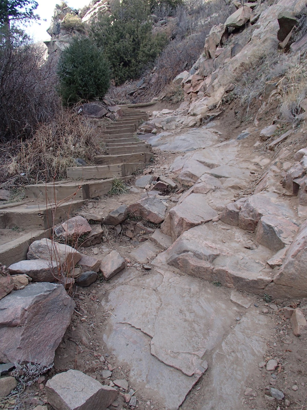
"The Stairs". Many a blood and testicle have been lost going down this. A bit of a right of passage to clear the entire section... now, can you make it up?
If you squint you can see the Plymouth Creek sign on the left, this is where you begin the lollipop. You can see the fallen stump on the right. You can ride up the backside of this on your way down - don't get too crazy with air over the top though, there's a tree that will humble you.

The views on the lollipop are spectacular. You can see all the way to downtown Denver in the background.

One of the many switchbacks on the way up. The approaches are pretty abrupt, and you can see that they're not well maintained.

You've reached the high point of the climb.

Elevation profile

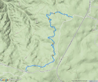
Overview map of the ride.

Below is a map view of the two loops. I've done this with the Plymouth Loop (described above) first, followed by the Red Mesa loop. Once you finish the big descent on Plymouth, hang a left at the fork and head up Red Mesa for more climbing. I did this in the clockwise direction. There's not really a place to get lost here, just stick to the main trail, and hold on for dear life on the way down.


Distance: 9.17 miles
Climb: 1719 feet
Time to beat: 1:46